


Ponts-de-Cé - Angers_J3

Gandon91
User
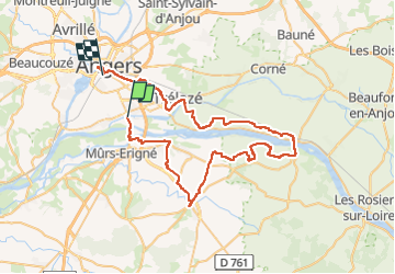

Length
66 km

Max alt
83 m

Uphill gradient
620 m
Km-Effort
74 km

Min alt
14 m

Downhill gradient
595 m
Boucle
No
Creation date :
2021-10-25 18:18:48.709
Updated on :
2022-08-11 13:10:11.113
--
Difficulty : Very easy

FREE GPS app for hiking
 SityTrail
IGN / Geographical institutes
SityTrail Plus
The world is yours!
About
Trail Bicycle tourism of 66 km to be discovered at Pays de la Loire, Maine-et-Loire, Les Ponts-de-Cé. This trail is proposed by Gandon91.
Description
Loire à Vélo Nantes à Angers
Positioning
Country:
France
Region :
Pays de la Loire
Department/Province :
Maine-et-Loire
Municipality :
Les Ponts-de-Cé
Location:
Unknown
Start:(Dec)
Start:(UTM)
686464 ; 5255857 (30T) N.
Comments